Empowering weather-critical UK infrastructure with substantially higher-resolution weather prediction data.
SOLUTIONS
Orographic will utilise NVIDIA's Earth2 digital twin to empower renewable energy & transport sectors with high resolution weather data. Using generative AI, weather simulations at fine scale resolutions, for dozens of atmospheric levels, down to sub kilometer resolution, can be run on domestic infrastructure.
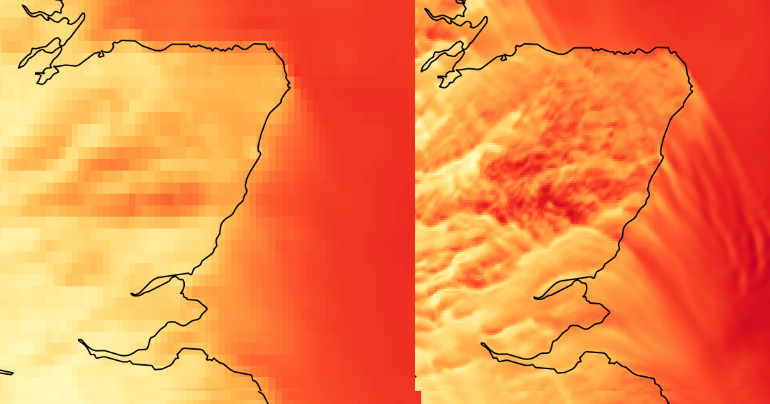
This software can equip climate-resilient infrastructure with high-fidelity site-specific weather information at a fraction of the cost. More importantly, the energy used by a single GPU to produce our intermediate 1.3km nest (figure 1), will be 0x less than needed from a traditional numerical prediction. Because of this, previously computationally demanding ensemble systems can generate the multitude of possible outcomes at a fraction of the cost of one previous run. This allows a significantly greater chance of an Orographic forecast capturing the presence of a microclimate-driven gust, or a convective-permitted downdraft. This added intelligence will add a layer of robustness to the renewable & transport sector.
Complementing Project Aardvark
Project Aardvark, powered by UK research, is fueling AI-driven accuracy in upper atmospheric boundary data. Orographic will digest that data to use an AI-curated model of the coarse atmosphere, and output hyper-local resolution weather data at the fine scale. AI models such as CorrDiff will learn the macroscale to microscale relationship between atmospheric input and variable hyper-resolution data. They will ingest AI-corrected boundary data, through Aardvark-derived data, or other radar-assimilated boundary data correction methods, to produce surface conditions at infrastructure-level resolution in seconds.
Climate resilience through energy use, not just weather intelligence.
Due to the increased throughput of Earth2, often as much as 0x that of traditional high resolution models, ensembles of Orographic's Earth2 models can be ran dozens of times and still achieve 100–300x lower energy consumption to traditional methods. This not only allows high spatial fidelity of weather data, but ultimately a prediction of the probability of local events, giving Orographic's solution a superior chance of capturing a high-cost event.
The same computational power that powered previous methods for a 10km model will be able to power a 0.4km model.
The Orographic Edge
SevereWeatherUpdates
SevereWeatherUpdates is the second largest weather site online by total following. Its extraordinary reach will allow AI-powered high resolution data to be used by a large percentage of the UK population immediately.
Ensemble Advantage
Orographic will be committed to streamlining regional super resolution models to the needs of infrastructure critical users in the renewables & transport sectors. The significantly lower costs associated with generative-AI will enable us to run dozens of ensemble forecasts for the price of a standard model at a higher resolution.
The Manchester Edge
Orographic will be situated in Manchester. This will allow climate-tech innovators to pilot and document initial use cases of Orographic's data. Orographic will curate the high resolution outputs to meet the needs of climate-critical businesses within the Manchester climate network, thus improve integration of AI-powered weather data in climate-critical businesses.